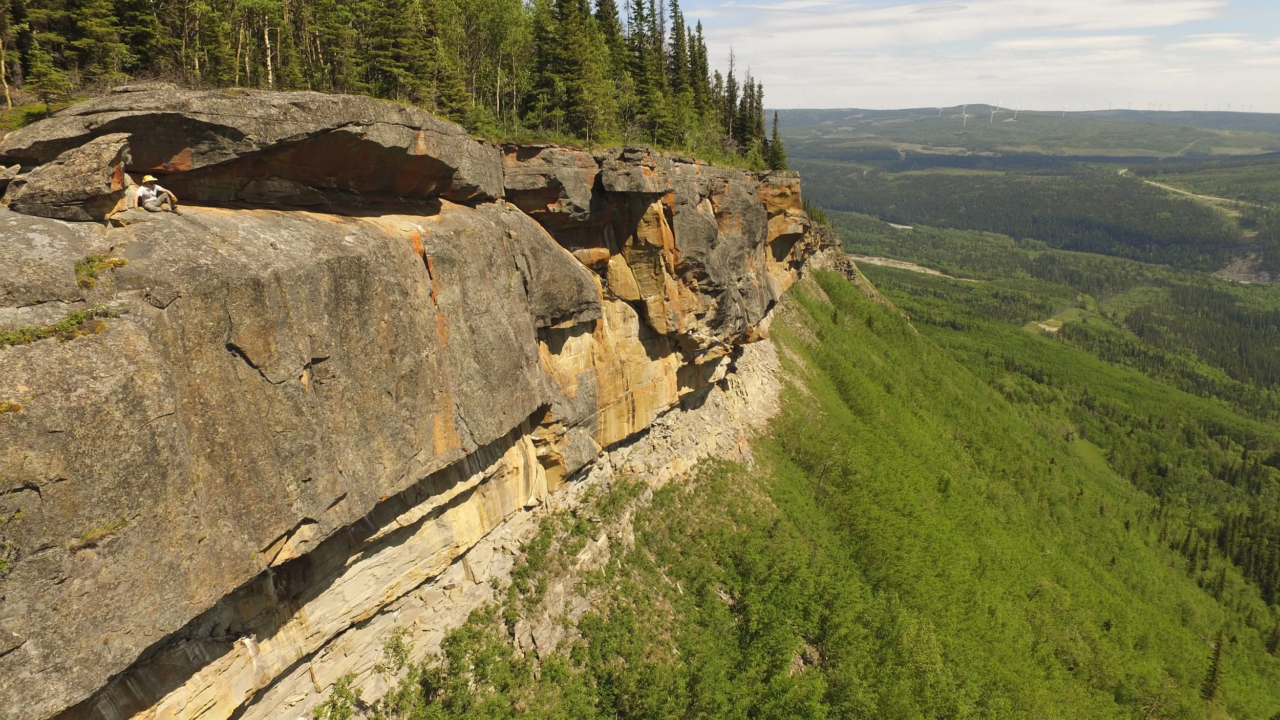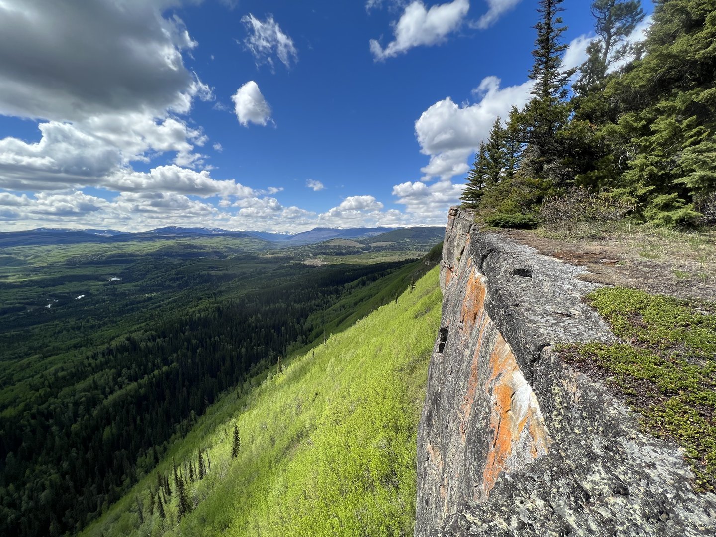

bergeron cliffs
Embark on a trek through serene aspen and pine forests, culminating at the breathtaking Bergeron Cliffs - a Tumbler Ridge icon. Take in the sweeping vistas of the Murray River valley, Tumbler Ridge, and the majestic Hart Ranges of the Rocky Mountains. For a full day adventure, consider pairing this trail with the Bergeron Falls.
Distance | Time:
6 km return | 3-4 hours
Elevation Gain: 400 m
Trail Rating:
Moderate - A long, steady climb.

Features:
Spectacular cliff-top hike, viewpoints.
Caution:
Huge, unbarricaded drop-offs.
-

Trails
The Bergeron Cliffs trail is 6 km return and takes 3 to 4 hours. The cliffs hike is rated moderate, with a steady uphill section. For a full day, this trail may be combined with the Bergeron Falls trail. See the Hiker’s Guide for more detailed information.
-

Training
The Bergeron Cliffs hiking trail provides a good training route for runners preparing for the Emperor’s Challenge (which leads over the summit of Mt Babcock, one of the mountains on the horizon). In places there is an airy, “running on the edge” experience.
-

History
In 1919 the Mount Bergeron ridge was first marked on a map as “Tumbler Range”, which was then changed to “Tumbler Ridge” on a 1920 map. It is said that the name originated from rocks tumbling down the slopes. If so, the rocks at the top end of Bergeron Cliffs would have been the most likely source, and ultimately would have given the community of Tumbler Ridge and the Tumbler Ridge Global Geopark their names.
-

Trip Link
On the return trip from Bergeron Cliffs, you can link up with the Bergeron Falls route by continuing along the cutline, following this connector trail to meet up with the trail to the falls.
-

Photography
After a short stretch through small closely spaced pine, the result of a past forest fire, the trail breaks into the open at the main cliffs. Excellent views of the Murray and Wolverine river valleys and the mountains to the west, as well as the Tumbler Ridge townsite, can be enjoyed from the safety of a spot set back from the drop-off.
-

Caution
This trail has huge unfenced drop-offs at the cliff edges. Children and pets should be supervised. This trail is in bear country; travel in groups and make noise. Please pack out what you packed in.
DIRECTIONS TO TRAILHEAD
From Tumbler Ridge, drive north towards Chetwynd on Hwy 29 for 6.5 km to the signed right turn onto a gravel road. Follow this road for 8 km to its end beside a large gravel pit. There is a sign at the trailhead.


thank you to our partners

experience tumbler ridge unfiltered. tag #tumblerridge to show us your adventures.